Eduqas A Level Geography Component 3: Tectonics | 38 mark essay | A* Revision Notes, Everything You Need To Know
18 views 0 purchase
Course
Tectonic Hazards
Institution
CCEA
This document provides a clearly structured break down for the entire Tectonics 38 mark essay in A level Eduqas Geography Component 3. It covers all the specification points with in-depth knowledge and detailed essay plans. This is including:
3.1.1 - Characteristics of the earth’s structure - me...
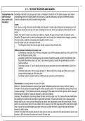
3.1.1 - TECTONIC PROCESSES AND HAZARDS
Characteristics of the Knowledge of the Earth’s structure goes as far back as Christopher Colombus in the 15th century. However, most modern
earth’s structure understanding comes from studying patterns of shock waves, caused by earthquakes, and layers with different densities,
(core, mantle, crust, chemical compositions and physical properties being identified.
boundaries)
Layers:
Core - the inner core is in the centre and the hottest part of the earth. It is solid, made of nickel and has temperatures of up to
500 degrees celsius. The outer core is the layer surrounding the inner core, which is a liquid layer but also made of iron and
nickel.
Mantle - The mantle is made of semi-molten rock called lava. Together, the upper and lower mantle are referred to as the
lithosphere. The upper mantle is called the asthenosphere, which is hot enough to be malleable without snapping or breaking.
The lower mantle is called the mesosphere, presenting 50% of earth’s volume.
Crust - this refers to the thin, outer layer of the earth
- The lithosphere refers to the crust and upper mantle, composed of solid and brittle rock.
Difference between continental and oceanic crust:
- Continental has a thick crust of 35-75 km and a lithosphere of up to 400 km whereas oceanic has a thin crust of 6-10 km
with the lithosphere reaching 120km.
- Continental is granitic (hard, granular igneous rock consisting of quartz and used as a building stone)/andesitic (dark,
fine-grained intermediate volcanic rock found in lava) whereas oceanic is basaltic (fine-grained volcanic rock with a
columnar structure).
- Continental crust has a 2.7 g/cm^3 density so does not subduct and oceanic crust has a higher density (3 g/cm^3) so
subducts.
- Continental crust is older, with the average age being 1.8 billion years, but the average age for the oceanic crust is
younger with the average age of 65 million years.
- Continental crust forms orogenic belts and cordillera whereas oceanic crusts form island arcs.
Discontinuities: a boundary between the layers of the earth.
Mohorovic - discontinuity between the crust and upper mantle. Earthquakes produce seismic waves, which are vibratory
movements of rock particles that spread through the surface and earth’s interior. This was divided into p-waves (pressure) and
s-waves (secondary). In 1909, Mohorovicic found in a seismograph, 200km away from the Earth’s epicentre, that S waves can’t
travel through the mantle but P waves are refracted by a high velocity medium.
Gutenberg - this established a discontinuity between the lower mantle and upper core. This is because the lower mantle above
the gutenberg line is solid and the core below is liquid molten and dense. This was found as both p and s waves can travel
through solid but only p waves can travel through liquid so seismic wave data showed s waves didn’t travel through. The area
within it is a narrow zone of around 3-5 miles. However, this is uneven as it lies 1800 miles below earth’s surface but the intense
heat in the earth is becoming dissipated causing the molten core to solidify and shrink, making the boundary sink deeper
beneath the earth’s surface.
Lehmann - this refers to the boundary between the inner core and outer core, where there is an abrupt increase of p and s wave
velocities at 3200 miles below the surface and is around 140 miles wide.
,Mechanisms of plate Internal heating and convection currents: the slow flow of the heat from the earth’s core to the surface is estimated at terawatts
movement (internal and are called convection currents. This is due to the radiogenic heat produced by the radioactive decay of isotopes in the
heating in the earth, mantle and crust and the primordial heat left over from the formation of the earth. The temperature and pressure decreases and
convection currents, it moves up towards the crust.
ridge push, slab pull)
Ridge push - a new crust is dragged along the top of a convection cell. The dense crust sinks back into the asthenosphere,
pulling new crust behind it. As the plate subducts, lighter material is melted off in the intense heat of the asthenosphere,
encouraging the crust to sink even more rapidly and pulling the plate along.
Slab pull - this ascending convection cell injects magma below the ocean ridges, pulling the plates apart. Doming occurs above
the rising convection current, causing the plate to slide under the influence of gravity.
Plate distribution and Plate distribution:
processes operating - Diverging margins at the Caribbean plate and African plate.
at different margins - Converging margins at the Juan de Fuca plate.
(diverging, - Transforming margins at the North American plate and Pacific plate, forming the San Andreas fault line.
converging,
transforming); and
tectonic activity at Margins: the lithosphere is divided into 7 large and 3 small plates, which can move in 3 different ways.
hotspots Diverging - this is where two plates move apart due to ridge push and slab pull. At divergent margins, magma domes up and
liquid magma seeps into the lithosphere, reading to the build up of mountain ranges and oceanic trenches. Landforms created
at divergent margins include shield volcanoes and mid-ocean ridges. The most famous example is the mid-Atlantic ridge where
the North American and Eurasian plates are separating.
Converging - these are where plates move towards each other. This is done in 3 ways. The first is continental-oceanic; this sees
denser oceanic crust subduct, melting the plate and resulting in the formation of volcanoes and earthquake activity. The second
is continental-continental; this is also known as collision margins, which leads to plates folding upwards, creating fold mountains.
The third is oceanic-oceanic; this sees the denser of two plates subduct, creating oceanic islands and island arcs.
Transforming - transform boundaries are where plates slide past each other horizontally and at different speeds, creating friction
build up and often leading to large earthquakes. The most famous example of a transform fault line in the San Andreas Fault,
where the North American and Pacific plates are sliding past each other. The strongest earthquake here occurred in 1906,
destroying much of the city and killing 600 people.
Hotspots: these are small areas away from plate margins with unusually high heat, linked to volcanic activity. This occurs due
to a plume of magma that rises from the asthenosphere. However, some have suggested it is due to weakness in the crust
caused by historical slab pull and ridge push. The magma pushes through the crust, forming lines of volcanoes on land and
islands in oceans. An example of an oceanic hotspot is the Hawaiian Islands and a continental hotspot is Yellowstone.
Global distribution of Yellowstone supervolcano:
tectonic hazards and This volcano is located in Western United States and comes from a magma chamber under 65 miles north-west. It is a high risk
their link to tectonic volcano due to it being solid rock and rising at 2 inches per year, but having the potential to liquify and move at a faster rate,
processes which can be dangerous as an eruption is overdue. The most recent eruptions occured 643,000 years ago, 1.3 million years ago
and 2.1 million years ago, each being greater than the last and each triggering an avalanche of wind, snow, mud and rock.
, La Garita Caldera supervolcano:
This is located in the San Juan mountains in Colorado, US. It is one of a number of calderas that formed during a massive
ignimbrite flare up in Colorado, Utah and Nevada 18-40 million years ago. Instead of a conical volcano that erupts red ava,
calderas occur when a build up of magma beneath the earth’s crust causes the rick to bulge and the pressure creates an
explosion. When the magma chamber is emptied, the rock collapses inwards and leaves a large, round depression. L:a Garita
stretches 22x47 miles and was last inactive 26 million years ago. It’s biggest eruption occurred 28 million years ago nand is
considered one of the most energetic eruptions on the planet
3.1.1 - TECTONIC PROCESSES AND HAZARDS
Characteristics of the physical hazard profile that influence its impact including magnitude (Mercalli and Richter scales, Volcanic Explosivity
Index), predictability, frequency, duration, speed of onset and areal extent.
Introduction:
- Physical hazard profiles illustrate the variation in the nature of tectonic hazards. This is a common way to compare and contrast different tectonic
hazards.
- Typical earthquake and volcanic profiles differ the most in terms of spatial predictability and frequency.
Measurement Definition How it's measured Evaluate
Richter scale This is the most common standard It is used to rate the magnitude of The scale was used to rank different
of measurement for earthquakes. It an earthquake through the amount high level earthquakes allowing a
was invented in 1935 by Charles of energy it releases. It uses a visual representation of comparison.
Richter in the California Institute of base-10 logarithmic scale so each Haiti 2010 was rated at 7 and Chile
Technology as a mathematical order of the magnitude is ten times 2010 was rated at 8.8.
device to compare the size of more intensive than the last one.It One weakness of this graph is that
earthquakes. measures the amplitude of the only accounting for the maximum
largest recorded seismic source ground motion and amplitude means
using a seismometer and recorded it doesn’t provide an overall picture
on a seismograph (x axis). It also of the hazard in terms of its spread,
measures the microns of amplified length of time and effects so may
maximum ground motion (y axis). not be accurate.
Additionally, it is only mostly
effective for regional earthquakes no
greater than m5.
Moment magnitude scale Scientists developed far more This uses seismograms in addition Like the Richter scale, this has been
sensitive seismometers with fast to what physically occurs during applied to earthquakes to see a
computers to record and interpret a the earthquake, which is known as visual comparison. For example,
broad spectrum of seismic signals the seismic moment. The seismic Long Island New York has 920
than was possible in the 1930s with moment is a physical quantity moderate earthquakes per year,
the Richter scale. proportional to the slip on the fault which has the equivalent energy to
The benefits of buying summaries with Stuvia:
Guaranteed quality through customer reviews
Stuvia customers have reviewed more than 700,000 summaries. This how you know that you are buying the best documents.
Quick and easy check-out
You can quickly pay through credit card or Stuvia-credit for the summaries. There is no membership needed.
Focus on what matters
Your fellow students write the study notes themselves, which is why the documents are always reliable and up-to-date. This ensures you quickly get to the core!
Frequently asked questions
What do I get when I buy this document?
You get a PDF, available immediately after your purchase. The purchased document is accessible anytime, anywhere and indefinitely through your profile.
Satisfaction guarantee: how does it work?
Our satisfaction guarantee ensures that you always find a study document that suits you well. You fill out a form, and our customer service team takes care of the rest.
Who am I buying these notes from?
Stuvia is a marketplace, so you are not buying this document from us, but from seller lolawhiteside08. Stuvia facilitates payment to the seller.
Will I be stuck with a subscription?
No, you only buy these notes for $10.64. You're not tied to anything after your purchase.