Surveying notes for SSC JE (to the point) all concepts covered
2 views 0 purchase
Course
State AE /JE
Institution
State AE /JE
Surveying notes tailored for State AE/JE candidates, presenting concise and focused concepts, meticulously formatted in MS Word for enhanced comprehension. Dive into this organized resource for a streamlined understanding of surveying principles, ideal for both academic and professional contexts.
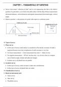
CHAPTER 1 – FUNDAMENTALS OF SURVEYING
• Survey term means “collection of data” and in civil engineering this data is the relative
position of a point above, on or below the earth surface with the help of linear measurement
(horizontal distance, vertical distance) and angular measurement (horizontal angle, vertical
angle).
• Relative position: is the position of a point with respect to a reference point.
VERTICAL PLANE
P HORIZONTAL PLANE
P Horizontal
Vertical angle
angle
distance
Vertical
Reference point
Horizontal distance
❖ Types of survey
1. Plane survey
• In this type of survey earth surface is considered as flat and the curvature of earth is
neglected because error due to neglection of earth curvature is very less.
• For linear measurement – 12 km measurement has only 8 – 10mm of error
• For angular measurement – 195 km2 area has only 1 sec of error when we compare
sum of interior angle of plane and spherical triangle.
• In plane survey all plumb lines are parallel.
2. Geodetic survey
• In this type of survey earth curvature is taken into consideration.
• In this type of survey all plumb lines are radial.
❖ Classification of survey
1. Based on instrument used
• Chain survey
• Tape survey
• Theodolite survey
, • Plane table survey
• EDM survey
• Statellite survey etc.
2. Based on the method
• Triangulation survey
• Traverse survey
• Trigonometry survey etc.
3. Based on place of survey
• Land survey
• Hydrographic survey etc.
4. Based on purpose of survey (***)
• Topographic survey – information about natural and man-made features.
• Geological survey – information about the surface and sub – surface is acquired like
mineral rock.
• Cadastral survey – information about property lines.
• Route survey – information about road
• Cross sectional survey – sewage related
❖ Principles of surveying
1. Working from whole to part.
2. To locate any point take at least 2 reference point or 2 independent measurement
❖ Operation of surveying
Reconnaissance or planning field observation data analysis map making
❖ Instruments used for various type of measurement
• For horizontal distance – tape, chain, tacheometer, EDM (electromagnetic distance
measuring instrument)
• For vertical distance – tacheometer, levelling instrument like dumpy level.
• For horizontal angle – magnetic compass, theodolite, total station, sextant etc.
• For vertical angle – sextant, clinometer, theodolite.
,❖ Scales
𝑀𝑎𝑝 𝑑𝑖𝑠𝑡𝑎𝑛𝑐𝑒
𝑠𝑐𝑎𝑙𝑒 =
𝐺𝑟𝑜𝑢𝑛𝑑 𝑑𝑖𝑠𝑡𝑎𝑛𝑐𝑒
❖ Representation of scale
Example: 100 m on ground is represented by 10 cm on the map
1. Engineer’s scale:
The following example will be written as 1cm = 10 m
2. Representative fraction (RF)
Here unit will be same on map distance and ground distance and the following
1
example will be written as
1000
RF has no unit.
❖ Shrinkage of map
• Drawing sheet or map shrink with temp. and humidity etc.
Exact reading = main scale reading + n(divisions) that coincides perfectly with main scale × least count of vernier(secondary) scale
❖ Types of vernier
Let 1 division of vernier be v and 1 division of main scale be s
A. Direct vernier
• Direct vernier has divisions are slightly shorter than those of the main scale
v<s
• n divisions on vernier scale are equal in length to (n - 1) divisons on main scale.
n v = (n – 1) s
𝒔𝒎𝒂𝒍𝒍𝒆𝒔𝒕 𝒅𝒊𝒗𝒊𝒔𝒊𝒐𝒏 𝒐𝒏 𝒎𝒂𝒊𝒏 𝒔𝒄𝒂𝒍𝒆
• Least count of vernier (L.C) =
𝒕𝒐𝒕𝒂𝒍 𝒏𝒐.𝒐𝒇 𝒅𝒊𝒗𝒊𝒔𝒊𝒐𝒏𝒔 𝒐𝒏 𝒗𝒆𝒓𝒏𝒊𝒆𝒓
• Main scale and vernier scale calibrate in same direction (reading increases in same
direction).
,B. Retrograde vernier
• Main scale and vernier scale calibrate in opposite direction.
• Retrograde vernier has divisions slightly longer than those of main scale.
v>s
• n divisions on the vernier are equal in length to (n + 1) divisions on main scale.
n v = (n + 1) s
𝒔𝒎𝒂𝒍𝒍𝒆𝒔𝒕 𝒅𝒊𝒗𝒊𝒔𝒊𝒐𝒏 𝒐𝒏 𝒎𝒂𝒊𝒏 𝒔𝒄𝒂𝒍𝒆
• Least count of vernier (L.C) =
𝒕𝒐𝒕𝒂𝒍 𝒏𝒐.𝒐𝒇 𝒅𝒊𝒗𝒊𝒔𝒊𝒐𝒏𝒔 𝒐𝒏 𝒗𝒆𝒓𝒏𝒊𝒆𝒓
C. Double vernier
• Double vernier can calibrate in both directions.
• Seen in theodolite.
D. Extended vernier
• n divisions on vernier are equal in length to (2n – 1) divisions on main scale.
n v = (2n – 1) s
𝒔𝒎𝒂𝒍𝒍𝒆𝒔𝒕 𝒅𝒊𝒗𝒊𝒔𝒊𝒐𝒏 𝒐𝒏 𝒎𝒂𝒊𝒏 𝒔𝒄𝒂𝒍𝒆
• Least count of vernier (L.C) =
𝒕𝒐𝒕𝒂𝒍 𝒏𝒐.𝒐𝒇 𝒅𝒊𝒗𝒊𝒔𝒊𝒐𝒏𝒔 𝒐𝒏 𝒗𝒆𝒓𝒏𝒊𝒆𝒓
POINTS TO REMEMBER
SHORT NOTES
• Pantagraph is a plan enlarging instrument
• Ghat tracer is a gradient finding instrument.
• Sounding is used to measure the depth below water surface.
• Fathometer is an instrument used for measuring depth in ocean.
• Range are the lines on which the soundings are taken.
• Telemeter is used for measurement of distance.
• Abney level (is fitted with a extended vernier) can be used as a clinometer.
• Cross staff, prism square and optical square are used for setting out right angle.
• Oblate spheroid closely represents the shape of earth.
,• Survey which consists of observation of stars, sun moon etc is known as astronomical
survey.
Types of survey Recommended scale
Building survey 1 : 1000
Town planning survey 1 : 5000
Topographic survey 1 : 25000
Route survey 1 : 10000
• Compensating error ∝ √𝐿, where L is the measured length
• Subtense bar is used to measure horizontal distance in undulated areas.
• Graphical scale is not affected due to shrinkage of map.
• Diagonal scale is used to measure three successive dimensions at a time.
• Maximum error on the drawing should not be greater than 0.25 mm.
, CHAPTER 2 – LINEAR MEASUREMENT AND CHAIN SURVEYING
❖ Approximate method or indirect method for linear measurement
• Pacing: In this distance travelled is determined by counting no. of steps manually. (1
step = 80 cm)
• Passometer: is a device which records the no. of steps.
• Pedometer: is a device which directly registers the distance travelled and not the no. of
steps.
• Oedometer:
It is a device that is attached to bicycle wheel and records the no. of revolution to
determine the distance travelled.
❖ Types of Surveying chain
1. Gunter’s or surveyor’s chain
66 feet long, consists of 100 links.
2. Engineer’s chain
100 feet long, consists of 100 links
3. Revenue chain
33 feet long, consists of 16 links
4. Metric chain
• Generally available is length 5 m, 10 m, 20 m, 30 m
• 30 m chain (150 links)
• 20 m chain (100 links)
• Tolerance limit:
✓ 5 meter chain = 5 meter ± 2 mm
✓ 10 meter chain = 10 meter ± 3 mm
✓ 20 meter chain = 20 meter ± 5 mm
✓ 30 meter chain = 30 meter ± 8 mm
Note: 1 mile = 80 gunter chain
1 acre = 10 × (gunter chain)2
,❖ Measuring tape
A. Cloth or linen tape:
Available in lengths of 10 m, 20 m, 25m and 30 meter.
Drawbacks: change in length due to shrinkage, stretching, dampness, temp. change and
also liable to get twisted.
B. Glass fiber tape
Advantage: they do not shrink or stretch due to temp. change.
C. Metallic tape
Available in length 20 m and 30 m.
More durable than linen tapes but gets affected by temp. variation and dampness.
D. Steel tape
Available in length 1 m – 50 m and the width is about 6 – 10 mm.
More accurate than metallic tape.
E. Invar tape
Consists of 64% steel and 36 % nickel.
Very accurate but expensive and liable to break easily.
❖ Instrument used in linear measurement (page 17)
1. Pegs
Range of upper cross section area is 2.5 to 7.5 cm2
Length is 15 cm to 90 cm.
Used to mark main stations and end points.
2. Arrow
Used to locate intermediate stations.
Placed on the ground after every chain length.
3. Ranging rod
Ranging is the process of locating no. of points on long survey line, also used
to extend the survey line and aligning the chain in a straight line.
Used to locate intermediate points.
Diameter = 30 mm, length = 2 – 3 m
Alternate white and red colour band and size of each band is 200 mm
, 4. Offset rods
5. Cross staff, prism square and optical square.
Used to measure 90-degree angle.
6. Plumb bob
It indicates whether a line is truly vertical or not and it represents the direction of gravity.
❖ Equipment to measure offset
1. Open cross staff
• It is used to set perpendicular offset only.
• It consist of two pair of vertical slit.
2. French cross staff
• It is used to set offset at angle 45 , 90 and 135
degree or we can say multiple of 45 degree.
• Octagonal shape.
3. Adjustable cross staff
• Used to set offset at any angle.
• Consist of main scale and vernier scale.
4. Optical square
• Used to set perpendicular offset only.
• Principle of optical square is double reflection.
• Index mirror and horizon are so placed that they make 45 degree angle.
5. Prism square
• Instead of using two mirror as used in optical square, a prism can be used having two
reflecting sides at an angle 45 degree.
NOTE:
• Most accurate method for setting offset at 90 degree is prism square/ optical square.
• Out of open cross staff, French cross staff and adjustable staff most accurate for
setting perpendicular offset is open cross staff.
, ❖ Important lines in Chain surveying
• Main line connects the main stations
• Base line is the longest line and divides
the area to be surveyed into almost two
equal parts. All measurements are
performed along the base line.
• Check line/proof line are used to
check the accuracy of a measurement.
• Tie line connects objects to survey
line, line joining the tie stations (all
lines that are used to perform survey)
• Tie station:
✓ These are station located on the main survey line.
✓ Used for locating interior detail of the area e.g: x, y
• offset is the measurement made in
lateral direction 𝜃 = 900
• If measurement is made in lateral
direction and 𝜃 ≠ 900 , then it is
called oblique offset.
Note: prism square is better as compared to optical square because with working the angle
between the mirrors in optical square may change.
❖ CHAIN SURVEY
• Suitable for small and open ground area.
• Principle is to divide complete survey area into no. of well conditioned triangle and
measuring the distance using chain.
• Distance is measured from outer to outer part of handle.
• Handles are made of brass and chain is made up of glavanized iron and mild steel.
• Diameter of link rods is 4 mm
The benefits of buying summaries with Stuvia:
Guaranteed quality through customer reviews
Stuvia customers have reviewed more than 700,000 summaries. This how you know that you are buying the best documents.
Quick and easy check-out
You can quickly pay through credit card or Stuvia-credit for the summaries. There is no membership needed.
Focus on what matters
Your fellow students write the study notes themselves, which is why the documents are always reliable and up-to-date. This ensures you quickly get to the core!
Frequently asked questions
What do I get when I buy this document?
You get a PDF, available immediately after your purchase. The purchased document is accessible anytime, anywhere and indefinitely through your profile.
Satisfaction guarantee: how does it work?
Our satisfaction guarantee ensures that you always find a study document that suits you well. You fill out a form, and our customer service team takes care of the rest.
Who am I buying these notes from?
Stuvia is a marketplace, so you are not buying this document from us, but from seller atulvashisht. Stuvia facilitates payment to the seller.
Will I be stuck with a subscription?
No, you only buy these notes for $4.49. You're not tied to anything after your purchase.